Yacht Drone Photography in Puget Sound: What to Expect from Professional Aerial Coverage
Professional yacht drone photography in Puget Sound captures your vessel from perspectives impossible to achieve from the water's surface — overhead orbitals that reveal hull lines, low-altitude passes that catch wake patterns, and wide-angle pulls that frame your boat against the Olympic Mountains or the San Juan Islands. Gray Yachts Media is a Pacific Northwest yacht media production company based in Seattle, specializing in 4K/6K drone footage, cinematic video, professional photography, and 3D virtual tours for vessels 40ft and above. Our aerial shoots are conducted by FAA Part 107–certified pilots who know Puget Sound's airspace, weather windows, and best visual backdrops intimately.

What Does a Professional Yacht Drone Session Include?
A professional drone shoot for a yacht on Puget Sound goes well beyond hovering overhead and pressing record. A typical session for a vessel in the 50–80ft range delivers:
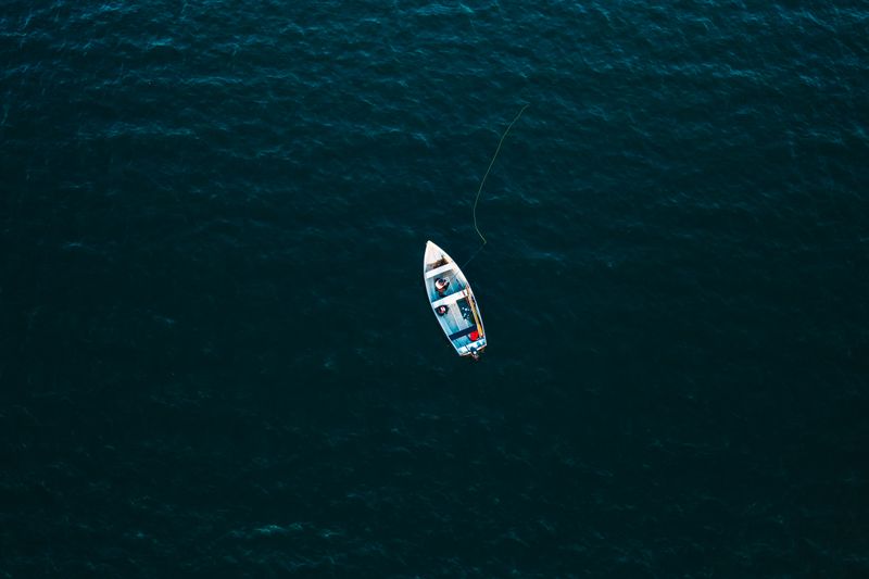
- Overhead reveal — A straight-down top shot showing full hull layout, deck plan, and waterline profile from approximately 200–300 feet AGL
- Orbit sequence — A 360° rotational pass at 50–100 feet that captures beam, freeboard, and superstructure detail from all angles
- Approach and pull — Drone starts tight to the bow and climbs slowly backward; creates the dramatic "departure" feel used in listing reels and showcase videos
- Follow shot — Vessel underway at 8–12 knots while the drone tracks alongside or behind, capturing wake, waterline, and motion in open water
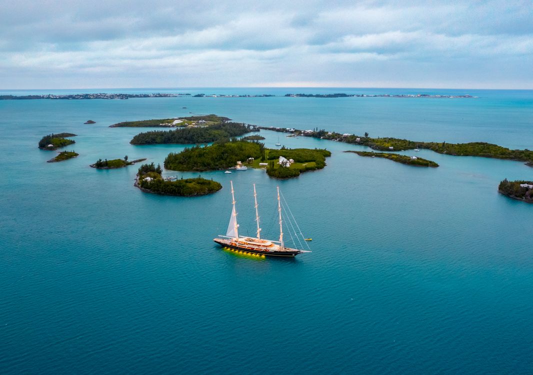
- Environmental wide — High-altitude frame (300–400 ft AGL) showing the boat against its surroundings — marina, mountain backdrop, or open Sound
For listing-focused shoots, the approach-and-pull and orbital sequences tend to perform best. For media and showcase content, the follow shot and environmental wide generate the most engagement.
Gray Yachts Media captures all aerial footage in 4K or 6K resolution at up to 60 frames per second, which allows for smooth slow-motion playback in post-production without sacrificing sharpness.
Why Aerial Footage Changes What Buyers See
From the dock or from a dinghy, you only ever see part of the picture. Drone footage is the only way to show a yacht's full context: its scale relative to a marina, the true run of its sheer line, the relationship between the cockpit and the transom. For a 65-foot motor yacht listed at Shilshole Bay, that difference matters enormously.
Ground-level photography communicates interior detail. Aerial photography communicates presence — the thing a buyer feels when they see the boat on the water and think, that's the one. A 60-footer looks like a tender when shot from eye level on a finger pier. Shot from 80 feet overhead, she fills the frame the way she deserves.
If you're preparing a vessel for sale in the Pacific Northwest, drone coverage paired with professional photography and a 3D virtual tour gives buyers a complete picture before they ever set foot aboard.
Airspace and Regulations: What Matters on Puget Sound
Not every drone operator can legally fly over Seattle's waterways. The Puget Sound region sits beneath some of Washington State's busiest airspace, and commercial drone operations here require more than just a consumer-grade drone and a YouTube account.
Professional aerial coverage for marine vessels requires:
- FAA Part 107 certification for the pilot in command — this is the commercial drone license, not the hobbyist registration
- LAANC authorization (Low Altitude Authorization and Notification Capability) for any flight within controlled airspace, which covers most of Seattle's waterfront including Elliott Bay and Lake Union
- Coordination with timing — flight windows near Seattle-Tacoma International Airport's Class B airspace can be as short as 15–30 minutes during peak approach corridors
- Visual line of sight at all times per Part 107 rules; beyond-visual-line-of-sight operations require a separate FAA waiver
Locations outside the major airspace rings — Gig Harbor, Anacortes, the San Juan Islands — offer more operational flexibility and frequently produce the most dramatic footage. The Olympic Mountains as a backdrop north of Port Townsend, or the ferry lanes threading through the San Juans, rank among the best drone backdrops in the Pacific Northwest.
Best Conditions for Drone Shoots on Puget Sound
Pacific Northwest weather is famously variable, but it follows patterns that experienced operators know how to read.
Ideal windows:
- Early morning, summer months (June–September) — Calm water, winds below 5 knots, excellent light from 6–9am before the marine layer burns off
- Late afternoon on clear days — Wind typically drops after 4pm; golden hour light from the west is spectacular against the Olympics
- 24–48 hours after a frontal passage — Post-system skies scrub the haze and deliver the clearest visibility of any PNW shooting window
Conditions to avoid:
- Sustained winds above 15 knots at altitude (affects footage stability even with 3-axis gimbals)
- Flat overcast "gray lid" days — colors wash out and the water reads as featureless steel
- Busy summer weekend traffic in the main Sound ferry corridors
Gray Yachts Media monitors conditions via NOAA's Puget Sound Marine Zone Forecasts and schedules all aerial shoots around optimal windows. We won't rush a drone session to fill a calendar slot.
How Much Does Yacht Drone Photography Cost in Seattle?
Drone-only aerial packages for a single vessel on Puget Sound typically run $400–$800 for a standalone session covering one location and approximately 60–90 minutes of flight operations. Most yacht owners bundle drone coverage with still photography and cinematic video into a full media day, which runs $1,200–$2,500 for vessels in the 50–80ft range depending on deliverables.
Key pricing factors:
- Vessel size and complexity — Larger vessels take longer to capture completely and may require multiple flight positions
- Location — Shoots within Seattle's LAANC-controlled airspace add coordination time; San Juan Islands sessions include travel
- Output deliverables — Raw aerial clips vs. color-graded highlight reels vs. full cinematic edit packages
- Session length — Extended underway sequences or multi-location days are priced accordingly
For Gray Yachts Media clients, aerial drone footage is typically packaged alongside professional yacht photography as part of a complete media day rather than a standalone service.

How to Prepare Your Vessel for an Aerial Shoot
The difference between a good drone session and an exceptional one often comes down to boat prep. A few steps that make a significant difference in final image quality:
- Clear the decks — Remove dock lines, fenders, wet gear, personal items, and anything else visible from above that would read as clutter
- Wash down — Saltwater residue, rust streaks, and dirt show clearly from overhead; a clean hull and topsides read as a maintained, cared-for vessel
- Stow the tender if possible — Davits and inflatables interrupt hull visual lines in top-down shots; if the dinghy can come down, it should
- Decide on shade covers — Biminis and Bimini extensions can look great or clutter the deck depending on angle; discuss with your photographer in advance
- Plan the underway route — If doing follow shots, have a clear 1–2 mile straight run in mind on calm water without heavy commercial traffic nearby
The San Juan Islands, the waters off Gig Harbor, and the stretch between Shilshole Bay Marina and Kingston all make excellent grounds for underway footage.
Frequently Asked Questions About Yacht Drone Photography in Puget Sound
How much does yacht drone photography cost in Seattle?
Drone-only aerial sessions for yachts on Puget Sound typically run $400–$800 for a standalone shoot. Most owners bundle aerial coverage with full media packages ranging from $1,200–$2,500 for a comprehensive media day covering vessels in the 50–80ft range.
Do commercial drone operators need permits to fly over Puget Sound?
Yes. Commercial drone operations require FAA Part 107 certification. Flights within Seattle's controlled airspace — including Elliott Bay, Lake Union, and surrounding waterways — also require LAANC authorization, which professional operators like Gray Yachts Media coordinate prior to every shoot.
What's the best time of year for aerial drone footage on Puget Sound?
June through September offers the most consistent shooting conditions in the Pacific Northwest. Early summer mornings — between 6 and 9am — typically deliver the calmest water and best light before the marine layer develops. The 24–48 hours following a Pacific frontal system also produce exceptional clarity.
Can drone footage be used for yacht listing videos?
Absolutely. Aerial footage is one of the highest-impact tools for yacht listings because it shows hull lines, true scale, and on-water surroundings in ways ground photography cannot. Combined with interior stills and a 3D virtual tour, drone footage gives remote buyers everything they need to make a confident decision before visiting.
Does Gray Yachts Media fly drones in the San Juan Islands?
Yes. Gray Yachts Media serves the full Pacific Northwest service area, including the San Juan Islands, Anacortes, Gig Harbor, and Puget Sound from Seattle south to Des Moines. Travel shoots are available for vessels 40ft and above.
Looking for professional yacht media in the Pacific Northwest? Contact Gray Yachts Media to discuss your aerial photography or full media package.
Related Articles
Stuart Island Anchorage: Prevost & Reid Harbors
Stuart Island, at the northwest edge of the San Juan Islands, offers two of the most protected anchorages in the Salish Sea. Prevost Harbor and Reid Harbor provide sand-and-mud holding in 25 to 30 feet and all-weather shelter from every quadrant.
Yacht Video Production in Seattle: What Cinematic Listing Footage Should Cover on Puget Sound
Professional yacht video production in Seattle layers four distinct camera perspectives — aerial drone, on-water gimbal, walkthrough Steadicam, and lifestyle handheld — into a single cinematic edit that sells a vessel before a buyer ever steps aboard.
Reading PNW Boating Weather Windows for Spring Passage Planning
A PNW boating weather window is a stretch of 48 to 96 hours when wind, swell, and pressure trends align for a coastal passage, and in spring, the Pacific Northwest typically delivers them only after the Aleutian Low retreats and the North Pacific High builds, usually from mid-April through June.