Reading PNW Boating Weather Windows for Spring Passage Planning
Reading PNW Boating Weather Windows for Spring Passage Planning
A PNW boating weather window is a stretch of 48 to 96 hours when wind, swell, and pressure trends align for a coastal passage, and in spring, the Pacific Northwest typically delivers them only after the Aleutian Low retreats and the North Pacific High builds, usually from mid-April through June.
When does a Pacific Northwest weather window actually open in spring, and how do you know it will hold long enough to commit?
That question is the entire job. A 48-foot trawler sits at a Shilshole slip in late April, tanks topped, crew briefed, bound for Ketchikan via the Inside Passage. The forecast looks workable. The barometer is climbing. But Puget Sound is the easy part. The decision the skipper is really making is about Cape Flattery, the Strait of Juan de Fuca, and the next low spinning down from the Gulf of Alaska. Spring on this coast does not hand out windows. It rents them, briefly, with conditions.
Why this matters
The cost of misreading a PNW weather window is rarely dramatic. It is usually expensive and demoralizing. A 50-foot motoryacht that leaves Neah Bay into a building southwesterly burns through fuel reserves fighting 6-foot wind waves on a 7-second period. A sailboat caught off Cape Flattery on the wrong side of a frontal passage loses a day hove-to and a crew member to seasickness for the rest of the trip.
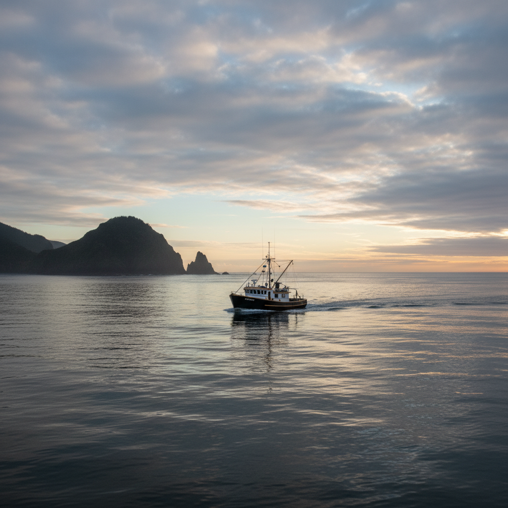
Good looks different. Good is a morning departure from Neah Bay onto a 4-foot northwest swell at 11 seconds, light north wind, barometer steady at 1022, with the next front modeled at least 60 hours out by both GFS and ECMWF. Good is boring.
Spring passage planning in the Pacific Northwest sits on two layers. The strategic layer is seasonal: you watch the synoptic pattern shift through April and May as the Aleutian Low weakens and the North Pacific High starts asserting itself. The tactical layer is the 72 hours before you cast off. Both layers matter. Skipping either is how people end up writing trip reports they would rather not write.
One useful number to anchor on: the PNW coast runs in roughly 10-day cycles of settled and unsettled weather through spring. You are not waiting for a season. You are waiting for a phase.
What a PNW weather window actually is
A weather window, in the working definition cruisers use, is a period when the conditions you will be sailing in are appropriate to complete the passage. Not perfect. Appropriate. The phrase matters because spring on this coast almost never gives you perfect.
For our 48-foot trawler bound for Southeast Alaska, "appropriate" decomposes into four things the skipper checks before every leg:
- Wind speed and direction at the route's exposed sections, not just the departure point.
- Swell height and period, with the period mattering as much as the height. A WNW 6 feet at 9 seconds is the threshold many coastal skippers treat as a serious-conditions line. The same 6 feet at 13 seconds is a different ocean.
- Pressure trend, because a steady or rising barometer says the system overhead is stable, and a falling one says a front is on the way.
- Frontal timing, meaning where the next low is and when it crosses your track.
The Pacific Northwest weather window question is rarely "is today good." It is "is the gap between this front and the next one long enough to get from here to there at hull speed, with margin."
The narrative spine: Puget Sound to Ketchikan, one decision at a time
The skipper's route breaks into three weather problems that look nothing alike. Treating them as one trip is the most common spring mistake.
Leg one: Puget Sound and the run to Port Angeles
Inside the Salish Sea, weather windows are mostly about wind, current, and visibility. Swell is not a factor. Puget Sound yachting in April can be glassy at dawn and a 20-knot southerly by 3 p.m. as thermal effects load the afternoon. Morning departures are the standard answer.
The trawler leaves Shilshole at 0500. By the time the afternoon westerly fills in, she is tucked into Port Angeles. This is the easy leg. It is also where crews build false confidence about the next one.
Leg two: the Strait of Juan de Fuca
The Strait is its own animal. Wind direction changes in the Strait of Juan de Fuca matter more than wind speed because the Strait acts as a venturi: westerlies accelerate as they funnel east, ebb currents stacked against a westerly build short, steep seas that pound a displacement hull. The interaction between flood/ebb and a 15-knot wind decides whether the crossing is comfortable or miserable.
The tactical answer is simple and almost always ignored: time your transit for slack or fair current, with wind under 15 knots, in the morning. The best time to cross the Strait of Juan de Fuca in spring is usually between 0600 and 1100 on a day when the synoptic pattern is between systems, not ahead of a front.
Leg three: Cape Flattery and the open coast
Round the cape and the calculus changes entirely. You are now in offshore passage timing, where swell period, gale warnings, and the position of the next North Pacific low decide everything. The Cape Flattery rounding is the real go/no-go on a northbound spring passage. Inside the Strait, you can always turn around. Once committed past the cape and heading up the west coast of Vancouver Island, the nearest bail-out is hours away.
The threshold most experienced PNW skippers use for committing to round Cape Flattery northbound in spring: wind 15 knots or less from a favorable quadrant, swell 8 feet or less at a period of 10 seconds or longer, and a forecast gap to the next gale of at least 48 hours.
Reading the tools: which forecast for which decision
No single tool answers every question. The skipper on the trawler uses a stack, and each layer has a job.
| Tool | Best for | Refresh | Where it falls short |
|---|---|---|---|
| NOAA marine zone forecasts (weather.gov) | Coastal and offshore zone wind, seas, gale warnings | 4x daily | Lower spatial resolution than gridded models |
| NDBC buoys (46005, 46041, 46087) | Real-time validation of forecast conditions offshore | Hourly | Single-point data only |
| Windy.com | Visualizing GFS vs. ECMWF vs. ICON across the route | Per model run | Easy to over-trust the prettiest model |
| PredictWind | Multi-model routing, departure planner | Per run | Subscription required for full features |
| Passage Weather | GRIB-based passage view across multiple days | 2x daily | Less granular near coast |
The working rule: NOAA for the official forecast and warnings, Windy for synoptic pattern reading, PredictWind or Passage Weather for routing, and NDBC buoys to ground-truth the forecast in the 12 hours before departure. If buoy 46041 off the Washington coast is reading 4 feet higher than the model said it would, the model is wrong about your day too.
Stacking GFS against ECMWF is the underrated move. When the two global models agree on the position of a low 72 hours out, confidence is high. When they disagree by 200 miles, your window is not a window. It is a guess.
The spring synoptic pattern, in plain English
Spring in the Pacific Northwest is a transition season. Through winter, the Aleutian Low parks itself in the Gulf of Alaska and fires storm after storm at the coast. Through summer, the North Pacific High builds and pushes the storm track north, giving the PNW its dry, settled stretch. Spring is the handoff.
From late March into May, the Aleutian Low retreats unevenly. Some weeks feel like winter. Others feel like June. High pressure systems in the Pacific Northwest start building further south, and when one of them sets up over the eastern Pacific for four or five days, you get the kind of window cruisers wait all winter for.
The signal to watch: a 1024+ millibar high anchoring near 40°N, 135°W, with no organized low pressure within 1,000 miles of your route. That is the configuration that delivers a clean spring window from Puget Sound north. When it shows up on a Sunday evening forecast for the following weekend, and both GFS and ECMWF agree, that is when crews start topping off tanks.
Crew, hull, and the honest conversation
The window is not only about the weather. It is about what your boat and your people can absorb.
A 60-foot semi-displacement trawler with paravanes and a Seakeeper handles a beam swell that would make a 40-foot sailboat miserable. Four experienced offshore sailors will push a window a delivery skipper would not give to two friends on their first passage north. Crew tolerance for boisterous conditions is the variable most often skipped in passage planning, and the one that ends trips early.
The conversation happens before fuel is ordered, not at the dock. Who has been seasick before. Who has stood a night watch alone. Who will be honest at hour 18 when they are not okay. Those answers narrow the window before any model does.
For a longer reference on hull and equipment matching to PNW coastal cruising, see our guide to choosing a vessel for Pacific Northwest passages and the companion piece on pre-departure systems checks for spring departures.
FAQ
What is the best time of year to plan a spring passage in the Pacific Northwest? Mid-April through early June is the working window for most northbound coastal passages from Puget Sound. The Aleutian Low has typically weakened by then, and the North Pacific High starts producing 4 to 7-day stretches of settled weather. Earlier than mid-April, you are still inside the winter pattern and weather windows for PNW boating are short and unreliable.
How many days in advance can I reliably forecast a PNW weather window? Three to five days is the honest answer. Beyond 72 hours, model agreement matters more than model confidence: if GFS and ECMWF still agree at the 96-hour mark on the position of the next low, the window is real. Past 7 days, you are looking at pattern signals, not a forecast.
What wave height and swell period is considered safe for coastal PNW passages? Most experienced PNW skippers treat WNW 6 feet at 9 seconds as the upper threshold for committing to an outer-coast passage in a typical cruising trawler or sailboat. Comfortable is more like 4 feet at 11 seconds or longer. Period matters as much as height: a short-period sea on the same wave height is a different and harder passage.
How does Juan de Fuca Strait affect weather window planning for northbound passages? The Strait of Juan de Fuca accelerates westerlies through its venturi shape, and the combination of wind against ebb current builds steep, short seas quickly. Plan transits for morning hours with wind under 15 knots and ideally a fair or slack current. The Strait is often the most uncomfortable leg of a passage that looks easy on a synoptic chart.
How do I use NDBC buoys to confirm a forecast window? Pull data from buoys 46041 (Cape Elizabeth), 46087 (Neah Bay), and 46005 (offshore Washington) in the 12 hours before departure. Compare actual wind, wave height, and wave period to what the forecast said those buoys should be reading right now. If reality is significantly worse than the forecast, your departure day is wrong too. NDBC buoy data is the cheapest sanity check in passage planning.
From the wheelhouse
Spring on this coast has a particular weight to it. The marinas thin out by October, the docks go quiet through January, and by April there is a kind of impatience in every slip. Boats want to leave. Owners check models at breakfast. The first real high of the season feels like an event.
The honest thing is that most of the spring is still winter, and the windows are stingier than people remember. The discipline is to wait one more cycle when the models disagree, to trust the buoy over the forecast, and to leave at first light when you finally do go. The season is short. The mistakes get logged for years.
Schedule a Tour →
Sources
- 48° North, What is a weather window?
- NOAA National Weather Service Marine Forecasts
- NDBC, National Data Buoy Center
- Windy.com, Multi-model marine forecasting
- PredictWind, Offshore routing and departure planner
- Passage Weather, GRIB-based passage forecasts
- Bluewater Cruising Association, Strategic vs. tactical passage planning
- Trawler Forum, PNW coastal swell discussion
- Cruisers Forum, Pacific Northwest synoptic patterns
- The Boat Galley, Crew tolerance and passage decisions
Related Articles
Stuart Island Anchorage: Prevost & Reid Harbors
Stuart Island, at the northwest edge of the San Juan Islands, offers two of the most protected anchorages in the Salish Sea. Prevost Harbor and Reid Harbor provide sand-and-mud holding in 25 to 30 feet and all-weather shelter from every quadrant.
Yacht Video Production in Seattle: What Cinematic Listing Footage Should Cover on Puget Sound
Professional yacht video production in Seattle layers four distinct camera perspectives — aerial drone, on-water gimbal, walkthrough Steadicam, and lifestyle handheld — into a single cinematic edit that sells a vessel before a buyer ever steps aboard.
Pre-Season Yacht Pre-Purchase Inspection PNW Checklist for 50ft Buyers
A first-time 50ft yacht buyer in the Pacific Northwest who skips the insurance binder survey loses an average of 4 to 6 weeks on closing, because most marine insurers in Washington and Oregon require a current condition report dated within 60 days before they will write the policy.