Stuart Island Anchorage: Prevost & Reid Harbors
Stuart Island Anchorage: Prevost & Reid Harbors
Stuart Island, at the northwest edge of the San Juan Islands, offers two of the most protected anchorages in the Salish Sea. Prevost Harbor and Reid Harbor provide sand-and-mud holding in 25 to 30 feet and all-weather shelter from every quadrant.
The Place
Stuart Island sits at latitude 48°40'N, longitude 123°12'W. It is roughly 8 nautical miles northwest of Roche Harbor and 6 miles south of the Canadian border at Boundary Pass. The island is entirely undeveloped save for a handful of private cabins and the Stuart Island Marine State Park facilities.
Two deep bays cut into the north and south shores. Prevost Harbor opens toward Boundary Pass. Reid Harbor faces the Strait of Georgia. A 200-yard trail connects them across the island's narrow neck. That trail is the only developed route between the two harbors.
From Friday Harbor, the run is 12 nautical miles northwest. That is a comfortable 45 minutes at trawler speed. From Roche Harbor, it is 8 nautical miles, about 30 minutes. From Sidney, BC, the crossing through Boundary Pass adds current considerations but is only 10 nautical miles.
The Window
July through September deliver the most reliable weather. Prevailing northwesterlies of 10 to 15 knots make both harbors lee shores with excellent protection. July averages 1.5 inches of rain. August averages less than 1.
June can work, but the ebb in Boundary Pass still runs hard. Spring tides push 4 to 6 knots through the pass. Fog is common in early mornings.
October is quieter but risky. The first fall storms arrive mid-month, typically from the southwest. Reid Harbor handles southwesterlies well. Prevost does not. If you are chasing late-season solitude, watch the 10-day forecast and have an alternate plan.
Tidal range runs 7 to 9 feet in summer. Slack at Boundary Pass is the gatekeeper for northern approaches.
The Route
Leg 1: Roche Harbor to Reid Harbor. 8 nautical miles, 30 minutes. Clearing customs at Roche is the standard southern approach. Depart through Mosquito Pass, then northwest past Pearl Island. The entrance to Reid Harbor is wide and well-marked. Drop the hook in 25 feet over sand-mud. Good holding. Mooring buoys and a public dock are available if you prefer a tie-up.
Leg 2: North to Prevost Harbor. 2 nautical miles, 10 minutes. A short hop around the island's west end. Cross open water and watch for Boundary Pass traffic. Prevost's entrance is straightforward from the north. Anchor in 25 to 30 feet near the head of the bay. Stern ties are rarely needed in settled weather.
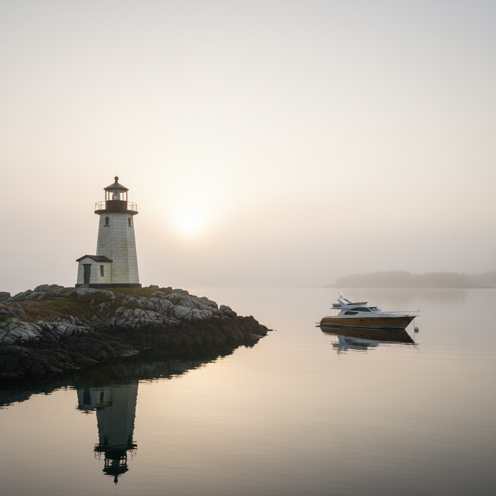
Leg 3: Prevost to Turn Point. 3 nautical miles, 15 minutes. Not a run to make with children on deck. The lighthouse sits at the northwest corner where Boundary Pass meets Haro Strait. Currents rip through here at up to 6 knots on a big ebb. Approach at slack or near-slack only. The reward is the view. Shipping lanes, the Gulf Islands, and Vancouver Island on a clear day.
What to Skip and What to Do
Skip the public dock in Reid Harbor if you value solitude. It is functional but exposed to passing skiff wakes and the noise of pump-out traffic.
Skip anchoring in Prevost during a southerly blow. The fetch from Boundary Pass wraps around and builds an unpleasant chop.
Do hike the harbor-to-harbor trail. Two hundred yards through old-growth fir and madrone, from the head of Prevost to the head of Reid. It takes five minutes and delivers the island's essential experience. Quiet forest between two sheltered seas.
Do walk out to Turn Point Lighthouse. Two miles one way from the trailhead at the west end of Prevost's road. Operational since 1893. The fog signal building, the keeper's cottage, the view over Boundary Pass. This is the Salish Sea at its most exposed and most compelling.
Do take a dinghy to the southwest side of Prevost Harbor at dusk. The cliffs catch the last light. Eagles roost in the firs above.
Provisioning & Practical
Fuel and water are available at Roche Harbor but not on Stuart Island. Come topped off. The nearest diesel is Roche, 8 nm south, or Friday Harbor, 12 nm east.
Ice is available at the Roche Harbor store during summer months.
| Facility | Location | Notes |
|---|---|---|
| Public dock | Reid Harbor, head of bay | 500-ft linear mooring for boats under 30 ft; hand-operated pump-out barge 100 yards east |
| Mooring buoys | Reid Harbor, mid-bay | 12 buoys for larger vessels; fill early in peak season |
| Anchoring | Both harbors | 25-30 ft over sand-mud; all-weather protection |
Cell signal. Verizon and AT&T fade to nothing once you are inside either harbor. T-Mobile may hold a bar at the entrance to Prevost. Download your charts before leaving Roche.
Current at the entrance. Reid's entrance is benign at any tide. Prevost sees 1 to 2 knots at peak ebb. Not a concern for most vessels but worth noting if you are single-handing.
| Harbor | Protection | Facilities | Noise Level |
|---|---|---|---|
| Prevost | Excellent from NW, N, E | None (anchoring only) | Very quiet |
| Reid | Excellent from S, SW, W | Dock, buoys, pump-out | Moderate near dock |
FAQ
Which is the best anchorage on Stuart Island for protection from all wind directions? For southwesterly weather, Reid Harbor offers complete shelter. For the dominant summer northwesterlies, Prevost Harbor is the flatter, quieter choice. Neither covers both directions. Pick based on the forecast.
How deep is the water in Stuart Island anchorages? Both Prevost and Reid Harbors have anchoring depths averaging 25 to 30 feet in the main basin, on sand and mud bottoms with good holding. A 5:1 scope with 160 feet of chain is adequate for most coastal cruising yachts.
Are there mooring buoys at Stuart Island? Yes. Reid Harbor has 12 seasonal buoys for larger vessels plus a 500-foot linear mooring system for boats under 30 feet. Prevost Harbor has no buoys or docks. Anchoring only.
Schedule a Tour →
Related Articles
Yacht Video Production in Seattle: What Cinematic Listing Footage Should Cover on Puget Sound
Professional yacht video production in Seattle layers four distinct camera perspectives — aerial drone, on-water gimbal, walkthrough Steadicam, and lifestyle handheld — into a single cinematic edit that sells a vessel before a buyer ever steps aboard.
Reading PNW Boating Weather Windows for Spring Passage Planning
A PNW boating weather window is a stretch of 48 to 96 hours when wind, swell, and pressure trends align for a coastal passage, and in spring, the Pacific Northwest typically delivers them only after the Aleutian Low retreats and the North Pacific High builds, usually from mid-April through June.
Pre-Season Yacht Pre-Purchase Inspection PNW Checklist for 50ft Buyers
A first-time 50ft yacht buyer in the Pacific Northwest who skips the insurance binder survey loses an average of 4 to 6 weeks on closing, because most marine insurers in Washington and Oregon require a current condition report dated within 60 days before they will write the policy.